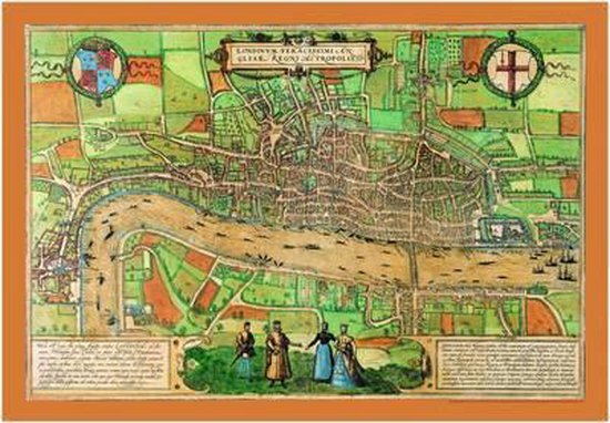
Map of Elizabethan London, 1572
Afbeeldingen
Artikel vergelijken
Productbeschrijving
The earliest entirely extant city plan of London, this map of the Elizabethan capital was first printed in 1572. As well as being a beautiful decorative piece, it also offers an invaluable insight into the geography of London and lives of its inhabitants. It features the infamous Tower of London, a bear baiting arena, the Charterhouse monastry, the monument at Chary-ncros , Old St Paul's Cathedral and even local wildlife in the grassy fields north of Holborn.
Productspecificaties
Wij vonden geen specificaties voor jouw zoekopdracht '{SEARCH}'.
Overige kenmerken
- Verpakking breedte
- 473 mm
- Verpakking hoogte
- 40 mm
- Verpakking lengte
- 687 mm
- Verpakkingsgewicht
- 46 g
EAN
- EAN
- 9781908402271
Je vindt dit artikel in
- Categorieën
-
Prijsinformatie en bestellen
Rapporteer dit artikel
Je wilt melding doen van illegale inhoud over dit artikel:
- Ik wil melding doen als klant
- Ik wil melding doen als autoriteit of trusted flagger
- Ik wil melding doen als partner
- Ik wil melding doen als merkhouder
Geen klant, autoriteit, trusted flagger, merkhouder of partner? Gebruik dan onderstaande link om melding te doen.