Shipwrecks Of The Northeast, Laminated Wall Maps History & Nature
Afbeeldingen
Artikel vergelijken
- Engels
- Losbladig
- 9781597754323
- 02 augustus 2012
- 1 pagina's
Samenvatting
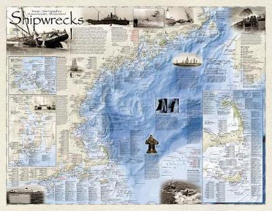
Shipwrecks of the Northeast illustrates more than 5,400 known shipwrecks on the untamed Atlantic coast of New England (Maine, Massachusetts, New Hampshire and Rhode Island). From Rhode Islands' Narragansett Bay to Maine's St. Croix River, each wreck site is symbolized to define the class, type and name of vessel accompanied by the date of sinking. Icons also indicate whether a ship was lost due to conflict or natural causes.
Locations of lifesaving stations and lighthouses, along with navigational beacons are also marked. Bathymetric and coastal features are clearly labeled. Captions and drawings highlight unique historical events such as the infamous sinking of the Italian luxury liner Andrea Doria off the coast of Nantucket in 1956. Wrecks featured on this map span from mid-1600s galleons to 20th-century naval ships, those lost in military conflict, foul weather, mutinies, unseen rocks, treacherous shoals, mechanical failures and a myriad of other events.
The map is encapsulated in heavy-duty 1.6 mil laminate which makes the paper much more durable and resistant to the swelling and shrinking caused by changes in humidity. Laminated maps can be framed without the need for glass, so the fames can be much lighter and less expensive.
- Map Scale = 1:723,000
- Sheet Size = 36'' x 28''
Productspecificaties
Wij vonden geen specificaties voor jouw zoekopdracht '{SEARCH}'.
Inhoud
- Taal
- en
- Bindwijze
- Losbladig
- Oorspronkelijke releasedatum
- 02 augustus 2012
- Aantal pagina's
- 1
- Illustraties
- Nee
Betrokkenen
- Hoofdauteur
- National Geographic Maps
- Hoofduitgeverij
- National Geographic Maps
Overige kenmerken
- Editie
- 2011
- Extra groot lettertype
- Nee
- Product breedte
- 46 mm
- Product lengte
- 734 mm
- Studieboek
- Ja
- Verpakking breedte
- 46 mm
- Verpakking hoogte
- 0 mm
- Verpakking lengte
- 734 mm
- Verpakkingsgewicht
- 141 g
EAN
- EAN
- 9781597754323
Je vindt dit artikel in
- Taal
- Engels
- Boek, ebook of luisterboek?
- Boek
- Studieboek of algemeen
- Studieboeken
Kies gewenste uitvoering
Bindwijze
: Losbladig
Prijsinformatie en bestellen
Rapporteer dit artikel
Je wilt melding doen van illegale inhoud over dit artikel:
- Ik wil melding doen als klant
- Ik wil melding doen als autoriteit of trusted flagger
- Ik wil melding doen als partner
- Ik wil melding doen als merkhouder
Geen klant, autoriteit, trusted flagger, merkhouder of partner? Gebruik dan onderstaande link om melding te doen.