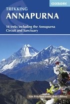
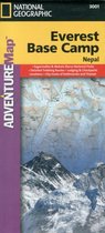
Annapurna-Nepal Travel Maps International Adventure Map
Afbeeldingen
Artikel vergelijken
- Engels
- Paperback
- 9781566955218
- 02 augustus 2012
- 1 pagina's
National Geographic
Samenvatting
&; Waterproof &; Tear-Resistant &; Travel Map
National Geographic's Adventure Map of Annapurna is an invaluable tool for travelers seeking to explore this remarkable mountain range, Nepal, and its capital Kathmandu. Designed to meet the needs of adventure travelers with its detailed, accurate information, this map includes the location of cities and towns with a user-friendly index and a clearly marked road network complete with major and minor roads and trekking routes. Expertly crafted and filled with specialty content, the map is the perfect companion to a guidebook.
A detailed topographic and trekking map of the Annapurna range is shown on one side of the print map. Helpful travel aids such as visitor centers, checkpoints, health posts, lodging, religious sites, and settlements are clearly indicated. The reverse side features a map of Nepal, as well as maps of Kathmandu and its commercial neighborhood of Thamel. In addition to restaurants, lodging, and shopping areas, a variety of resources are indicated on these inset maps as well including embassies/consulates, international organizations, places of worship, banks, post offices, police stations, bus stops, and more.
Every Adventure Map is printed on durable synthetic paper, making them waterproof, tear-resistant and tough &; capable of withstanding the rigors of international travel.
- Map Scale = 1:135,000
- Sheet Size = 36'' x 24''
- Folded Size = 4.25'' x 9.25''
Productspecificaties
Inhoud
- Taal
- en
- Bindwijze
- Paperback
- Oorspronkelijke releasedatum
- 02 augustus 2012
- Aantal pagina's
- 1
- Illustraties
- Nee
Betrokkenen
- Hoofdauteur
- National Geographic
- Hoofduitgeverij
- National Geographic Maps
Overige kenmerken
- Extra groot lettertype
- Nee
- Product breedte
- 108 mm
- Product hoogte
- 13 mm
- Product lengte
- 235 mm
- Studieboek
- Nee
- Verpakking breedte
- 116 mm
- Verpakking hoogte
- 11 mm
- Verpakking lengte
- 226 mm
- Verpakkingsgewicht
- 240 g
EAN
- EAN
- 9781566955218
Je vindt dit artikel in
- Categorieën
- Taal
- Engels
- Boek, ebook of luisterboek?
- Boek
- Beschikbaarheid
- Leverbaar
- Studieboek of algemeen
- Algemene boeken
Reviews
Negatief, positief, neutraal: we zetten een review altijd online. We controleren wel eerst of ’ie voldoet aan onze reviewvoorwaarden en niet nep is. We controleren ook of ’ie is geschreven door iemand die het artikel heeft gekocht via bol.com en zetten dit er dan bij. De controles gebeuren automatisch, al kijken er soms mensen mee. Bol.com betaalt niet voor reviews. Als een reviewer door een andere partij is vergoed, staat dit in de review zelf.
Negatief, positief, neutraal: we zetten een review altijd online. We controleren wel eerst of ’ie voldoet aan onze reviewvoorwaarden en niet nep is. We controleren ook of ’ie is geschreven door iemand die het artikel heeft gekocht via bol.com en zetten dit er dan bij. De controles gebeuren automatisch, al kijken er soms mensen mee. Bol.com betaalt niet voor reviews. Als een reviewer door een andere partij is vergoed, staat dit in de review zelf.
-
Mooie stevige kaart
Positieve punten
- Praktisch toepasbaar
- Volledig
- up to date
Mooie kaart, die zowel scheur- als waterbestendig is. Leuk om de route van het annapurna circuit er op te bekijken, in combinatie met de hoogtes.
Vond je dit een nuttige review?20
Kies gewenste uitvoering
Prijsinformatie en bestellen
De prijs van dit product is 23 euro en 48 cent.- Bestellen en betalen via bol
- Prijs inclusief verzendkosten, verstuurd door MyBoeken.nl
- 30 dagen bedenktijd en gratis retourneren
- Wettelijke garantie via MyBoeken.nl
Anderen bekeken ook


Vaak samen gekocht


Rapporteer dit artikel
Je wilt melding doen van illegale inhoud over dit artikel:
- Ik wil melding doen als klant
- Ik wil melding doen als autoriteit of trusted flagger
- Ik wil melding doen als partner
- Ik wil melding doen als merkhouder
Geen klant, autoriteit, trusted flagger, merkhouder of partner? Gebruik dan onderstaande link om melding te doen.