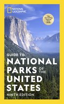
Colorado Trail North, Monarch To Denver Monarch to Denver
Afbeeldingen
Sla de afbeeldingen overArtikel vergelijken
Auteur:
National Geographic
- Engels
- Losbladig
- 9781566956956
- 23 juni 2017
- 1 pagina's
National Geographic
National Geographic ken je misschien van tv en de tijdschriften maar ze doen nog meer. Het merk is in samenwerking met Bresser (een merk dat al meer dan vijftig jaar verrekijkers en telescopen ontwikkelt) zijn eigen producten op de markt gaan brengen. Vanaf nu kun je zelf op ontdekkingstocht gaan en onderzoek uitvoeren met de producten van National Geographic. Ga je ’s nachts op pad? Ga dan voor een nightvision verrekijker van National Geographic, zo zie je altijd wat er ’s nachts gebeurt. Wil je exact weten wat voor weer het is, voor je op pad gaat? Bekijk dan eens de weerstations van dit merk. Installeer buiten de sensoren en je kunt binnen precies aflezen wat voor weer het is. Ga voor een verrekijker als je op wandeltocht gaat, of een telescoop als je de sterren eens goed wilt bekijken. Ben jij klaar om te ontdekken?
Samenvatting
&; Waterproof &; Tear-Resistant &; Topographic Map
The Colorado Trail North Topographic Map Guide has been designed as the perfect traveling companion when navigating the north section of The Colorado Trail. In a state known for its trails, The Colorado Trail is Colorado's premier long distance trail. Conceived in 1973 and completed in 1987, the trail runs 486 miles between Denver and Durango, traversing some of the most spectacular scenery in the state.
The Colorado Trail is often started at its north terminus in Waterton Canyon just outside of Denver. When traveling from north to south the trail follows the South Platte River and quickly climbs into the Lost Creek Wilderness. From here the trail crosses into Holy Cross Wilderness near Leadville. The trail then skirts the eastern slope of the Sawatch Range and passes beneath Mount Elbert, the highest mountain in Colorado. Next comes the Collegiate Peaks Wilderness with its multiple 14ers before finally joining with the Collegiate Loop near Monarch Pass. The Colorado Trail from Monarch to Durango is then picked up on the south Topographic Map Guide. Each page is centered on the trail and overlaps with adjacent pages so there is little chance of getting lost. Along the bottom of each page is a trail profile that shows the distance between passes, camping areas, and trail access points. The map and trail profile provide a step by step visual guide to hiking the trail, mile by rugged mile.
Expertly researched and created in partnership with local land management agencies including The Colorado Trail Foundation, this map guide provides detailed topographic maps, interesting history, bike detour maps, and a resupply location chart shows distances, and services available at each resupply point.
More convenient and easier to use than folded maps, but just as compact and lightweight, National Geographic's Topographic Map Guide booklets are printed on ''Backcountry Tough'' waterproof, tear-resistant paper with stainless steel staples. A full UTM grid is printed on the map to aid with GPS navigation.
- Map Scale = 1:75,000
- Folded Size = 4.25'' x 9.38''
Productspecificaties
Wij vonden geen specificaties voor jouw zoekopdracht '{SEARCH}'.
Inhoud
- Taal
- en
- Bindwijze
- Losbladig
- Oorspronkelijke releasedatum
- 23 juni 2017
- Aantal pagina's
- 1
- Illustraties
- Nee
Betrokkenen
- Hoofdauteur
- National Geographic
- Hoofduitgeverij
- National Geographic Maps
Overige kenmerken
- Editie
- 2018
- Extra groot lettertype
- Nee
- Product breedte
- 108 mm
- Product lengte
- 237 mm
- Studieboek
- Nee
- Verpakking breedte
- 108 mm
- Verpakking hoogte
- 3 mm
- Verpakking lengte
- 237 mm
- Verpakkingsgewicht
- 44 g
EAN
- EAN
- 9781566956956
Kies gewenste uitvoering
Bindwijze
: Losbladig
Prijsinformatie en bestellen
De prijs van dit product is 16 euro en 99 cent.
2 - 3 weken
Verkoop door bol
- Gratis verzending door bol vanaf 20 euro
- Ophalen bij een bol afhaalpunt mogelijk
- 30 dagen bedenktijd en gratis retourneren
- Dag en nacht klantenservice
Anderen bekeken ook


Rapporteer dit artikel
Je wilt melding doen van illegale inhoud over dit artikel:
- Ik wil melding doen als klant
- Ik wil melding doen als autoriteit of trusted flagger
- Ik wil melding doen als partner
- Ik wil melding doen als merkhouder
Geen klant, autoriteit, trusted flagger, merkhouder of partner? Gebruik dan onderstaande link om melding te doen.