Hopping Greek Islands Travel Guide Maps- Corfu Complete Topographic Map Atlas 1 30000 Greece Ionian Sea Hiking & Walking in Greek Islands with Othonoi, Ereikoussa, Mathraki, Paxos, Antipaxos Islands: Trails, Hikes & Walks Topographic Map
Afbeeldingen
Artikel vergelijken

Uitgever: Createspace Independent Publishing Platform
Auteur:
Sergio Mazitto
- Engels
- Paperback
- 9781718610903
- 01 mei 2018
- 40 pagina's
Samenvatting
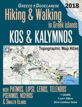
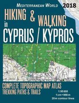
Updated 2018 edition. Large scale, highly detailed topographic map 1:30.000 for hiking and trekking, printed as an atlas book (with overlapping pages).
Complete map of the island of Corfu, Greece, with smaller nearby islands, covering great walks and wonderful hiking trails in the area. In addition to the island of Corfu, the maps also include Paxi (Paxoi), the smallest island group within the Ionian Islands (the Heptanese) with their largest islands of Paxos and nearby Antipaxos as well as the smaller islets. Also covered are the Diapontia Islands including Othonoi (Othoni), Ereikoussa, Mathraki, as well as the islets and rocks of Diakopo, Diaplo, Karavi, Kastrino, Leipso, Ostrako, Plaka, Plateia and Tracheia. Vido, Lazareto (Lazaretto, formerly known as Aghios Dimitrios) and Pontikonisi islands are also covered.
20 meter contour lines, road network, trails & paths, transportation, food, campsites, shelters, guest houses & hotels.Mercator projection with both UTM and WGS84 coordinate grids.
The map scale of 1:30000 (1 cm = 300 meters) provides a wealth of detail while keeping low the weight of the atlas itself. The largepage format of 8.5x11in minimizes page count and along with an overlapping map design allows for comfortable navigation.
The details included in the topographic maps of this atlas were specifically selected to be useful for trekkers, hikers and walkers ofall interests, and make it easy to plan and enjoy both short excursions and hikes as well as long multi-day adventures along themain marked routes and/or adjacent trails and paths, which are also shown on the maps.
With this ultralight atlas you will always have a detailed, reliable, information-rich, battery-independent, shatter-proof map for youradventure.
Productspecificaties
Wij vonden geen specificaties voor jouw zoekopdracht '{SEARCH}'.
Inhoud
- Taal
- en
- Bindwijze
- Paperback
- Oorspronkelijke releasedatum
- 01 mei 2018
- Aantal pagina's
- 40
- Illustraties
- Nee
Betrokkenen
- Hoofdauteur
- Sergio Mazitto
- Hoofduitgeverij
- Createspace Independent Publishing Platform
Overige kenmerken
- Extra groot lettertype
- Nee
- Product breedte
- 216 mm
- Product hoogte
- 3 mm
- Product lengte
- 279 mm
- Studieboek
- Nee
- Verpakking breedte
- 216 mm
- Verpakking hoogte
- 3 mm
- Verpakking lengte
- 279 mm
- Verpakkingsgewicht
- 0.15 kg
EAN
- EAN
- 9781718610903
Je vindt dit artikel in
- Land
- Griekenland
- Taal
- Engels
- Boek, ebook of luisterboek?
- Boek
- Regio
- Zuidoost-Europa, Balkan
Kies gewenste uitvoering
Bindwijze
: Paperback
Prijsinformatie en bestellen
De prijs van dit product is 13 euro en 99 cent.
2 - 3 weken
Verkoop door bol
- Gratis verzending door bol vanaf 20 euro
- Ophalen bij een bol afhaalpunt mogelijk
- 30 dagen bedenktijd en gratis retourneren
- Dag en nacht klantenservice
Anderen bekeken ook

Rapporteer dit artikel
Je wilt melding doen van illegale inhoud over dit artikel:
- Ik wil melding doen als klant
- Ik wil melding doen als autoriteit of trusted flagger
- Ik wil melding doen als partner
- Ik wil melding doen als merkhouder
Geen klant, autoriteit, trusted flagger, merkhouder of partner? Gebruik dan onderstaande link om melding te doen.