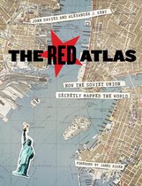
The Red Atlas - How the Soviet Union Secretly Mapped the World How the Soviet Union Secretly Mapped the World
Afbeeldingen
Sla de afbeeldingen overArtikel vergelijken
Auteur:
John Davies
Alexander J. Kent
- Engels
- Hardcover
- 9780226389578
- 17 oktober 2017
- 272 pagina's
John Davies
John Davies is a native of the Rhondda. He was educated in schools in Treorci, Bwlchllan and Tregaron and at University College, Cardiff, and Trinity College, Cambridge. He taught at the University Colleges of Swansea and Aberystwyth and was for eighteen years the Warden of Neuadd Pantycelyn, Aberystwyth. His other publications include Cardiff and the Marquesses of Bute, Hanes Cymru, Broadcasting and the BBC in Wales, The Making of Wales, The Celts and Cardiff: a Pocket Guide. He is the consultant editor of The Encyclopaedia of Wales. His wife comes from Blaenau Gwent and they have two daughters and two sons.
Samenvatting
Nearly thirty years after the end of the Cold War, its legacy and the accompanying Russian-American tension continues to loom large. Russia's access to detailed information on the United States and its allies may not seem so shocking in this day of data clouds and leaks, but long before we had satellite imagery of any neighborhood at a finger's reach, the amount the Soviet government knew about your family's city, street, and even your home would astonish you. Revealing how this was possible, The Red Atlas is the never-before-told story of the most comprehensive mapping endeavor in history and the surprising maps that resulted. From 1950 to 1990, the Soviet Army conducted a global topographic mapping program, creating large-scale maps for much of the world that included a diversity of detail that would have supported a full range of military planning. For big cities like New York, DC, and London to towns like Pontiac, MI and Galveston, TX, the Soviets gathered enough information to create street-level maps. What they chose to include on these maps can seem obvious like locations of factories and ports, or more surprising, such as building heights, road widths, and bridge capacities. Some of the detail suggests early satellite technology, while other specifics, like detailed depictions of depths and channels around rivers and harbors, could only have been gained by actual Soviet feet on the ground. The Red Atlas includes over 350 extracts from these incredible Cold War maps, exploring their provenance and cartographic techniques as well as what they can tell us about their makers and the Soviet initiatives that were going on all around us. A fantastic historical document of an era that sometimes seems less distant, The Red Atlas offers an uncanny view of the world through the eyes of Soviet strategists and spies.
Productspecificaties
Wij vonden geen specificaties voor jouw zoekopdracht '{SEARCH}'.
Inhoud
- Taal
- en
- Bindwijze
- Hardcover
- Oorspronkelijke releasedatum
- 17 oktober 2017
- Aantal pagina's
- 272
- Illustraties
- Nee
Betrokkenen
- Hoofdauteur
- John Davies
- Tweede Auteur
- Alexander J. Kent
- Hoofduitgeverij
- University Of Chicago Press
Overige kenmerken
- Extra groot lettertype
- Nee
- Product breedte
- 18 mm
- Product hoogte
- 2 mm
- Product lengte
- 24 mm
- Studieboek
- Ja
- Verpakking breedte
- 173 mm
- Verpakking hoogte
- 29 mm
- Verpakking lengte
- 234 mm
- Verpakkingsgewicht
- 977 g
EAN
- EAN
- 9780226389578
Kies gewenste uitvoering
Kies je bindwijze
(2)
Prijsinformatie en bestellen
De prijs van dit product is 26 euro en 99 cent.
Op voorraad
Voor 23:59 uur besteld, donderdag in huis
Verkoop door bol
- Prijs inclusief verzendkosten, verstuurd door bol
- Ophalen bij een bol afhaalpunt mogelijk
- 30 dagen bedenktijd en gratis retourneren
- Dag en nacht klantenservice
- Doordeweeks ook ’s avonds in huis
Shop dit artikel

Anderen bekeken ook

Rapporteer dit artikel
Je wilt melding doen van illegale inhoud over dit artikel:
- Ik wil melding doen als klant
- Ik wil melding doen als autoriteit of trusted flagger
- Ik wil melding doen als partner
- Ik wil melding doen als merkhouder
Geen klant, autoriteit, trusted flagger, merkhouder of partner? Gebruik dan onderstaande link om melding te doen.