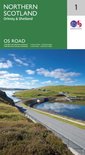
Ordnance Survey: North Scotland. Orkney & Shetland
Afbeeldingen
Artikel vergelijken
Ordnance Survey
"Ordnance Survey (OS) is a national mapping agency in the United Kingdom which covers the island of Great Britain. It is one of the world's largest producers of maps. Since 1 April 2015 it has operated as Ordnance Survey Ltd, a government-owned company, 100% in public ownership. The Ordnance Survey Board remains accountable to the Secretary of State for Business, Energy and Industrial Strategy. It is also a member of the Public Data Group.
(Bron: Wikipedia. Beschikbaar onder de licentie Creative Commons Naamsvermelding/Gelijk delen.)"
(Bron: Wikipedia. Beschikbaar onder de licentie Creative Commons Naamsvermelding/Gelijk delen.)"
Samenvatting
The OS Roadmaps series are single sided folded maps, the 8 maps provide GB 1: 250 000 coverage to enable the end user to navigate and plan their road journey. The maps include all motorways, primary routes and A roads plus detailed tourist information including National Parks, Country Parks and World Heritage sites and a useful town and city gazetteer. The eight maps in the series are Northern Scotland, Orkney & Shetland, Western Scotland and the Western Isles, Southern Scotland and Northumberland, Northern England, East Midlands and East Anglia, Wales/Cymru and West Midlands, South West England and South East England.
Productspecificaties
Wij vonden geen specificaties voor jouw zoekopdracht '{SEARCH}'.
Overige kenmerken
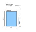
- Verpakking breedte
- 131 mm
- Verpakking hoogte
- 15 mm
- Verpakking lengte
- 238 mm
- Verpakkingsgewicht
- 130 g
EAN
- EAN
- 9780319263433
Je vindt dit artikel in
- Categorieën
- Land
- Schotland
- Regio
- West-Europa, Verenigd Koninkrijk
- Taal
- Engels
- Boek, ebook of luisterboek?
- Boek
Prijsinformatie en bestellen
Vaak samen gekocht

Rapporteer dit artikel
Je wilt melding doen van illegale inhoud over dit artikel:
- Ik wil melding doen als klant
- Ik wil melding doen als autoriteit of trusted flagger
- Ik wil melding doen als partner
- Ik wil melding doen als merkhouder
Geen klant, autoriteit, trusted flagger, merkhouder of partner? Gebruik dan onderstaande link om melding te doen.